Sale on canvas prints! Use code FAXEBY at checkout for a special discount!


by Phil Cardamone
$28.00
Design Location
Color
Image Size
Product Details
Our Bella / Canvas t-shirts are made from a 50% cotton / 50% polyester blend and are available in five different sizes. All t-shirts are machine washable.
Design Details
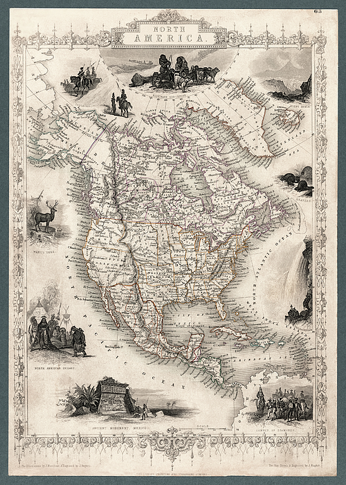
Atlas map of North America including the United States, Mexico, Central America, Caribbean islands, including detailed boundaries, place names, and... more
Ships Within
1 - 2 business days
Atlas map of North America including the United States, Mexico, Central America, Caribbean islands, including detailed boundaries, place names, and illustrations. The map appears remarkably accurate for the date when it was first made, 1851. This is an enhanced, restored reproduction of an antique map. Original source: "The Illustrated Atlas, And Modern History Of The World Geographical, Political, Commercial & Statistical." Includes decorative vignette engravings depicting Alaskan dog sleds, Mount Hekla, Beavers, Niagara Falls, ancient monument of Mexico, North American Indians, Wapiti Deer, and Cossacks. Map shows the states admitted to the Union at the time plus various territories. Alaska is designated as Russian America.
I have selected interesting, old 19th and early 20th century graphic images for digital restoration and editing. The images were then adjusted and brightened to make the images suitable for display and other purposes. The resulting image brings out many...
I live in the United States and use mostly Nikon and Sony equipment. My work includes fine art photography, B&W imagery, and enhanced, restored reproductions of old images and maps. Many of my images displayed here can be licensed through http://licensing.pixels.com. Please contact me for any special needs concerning the use of my images. Thank you for stopping by and looking at my work. Feel free to browse my images and comment, if you wish. The 5 x 7 greeting card size is suitable for framing if you would like a small print of one of my images. Please note that images on this site may not be used for any commercial publication or on any personal website without written permission. It is illegal to copy, post, scan or duplicate...
$28.00


There are no comments for North America Map 1851 with illustrations and boundaries. Click here to post the first comment.