Sale on canvas prints! Use code FAXEBY at checkout for a special discount!

Boundary: Bleed area may not be visible.


by Phil Cardamone
$58.00
Size
Orientation
Image Size
Background Color
Product Details
Our premium yoga mats are 24" wide x 72" tall x 0.25" thick and made from natural rubber with a blended microfiber top surface. The top of the mat has the image printed on it, and the back is solid black with textured dimples for better floor grip.
Design Details
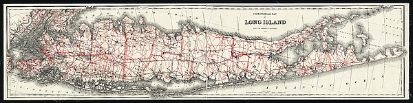
Long Island Map published 1892, a digitally restored historic map, showing roads and railroads towards end of 19th Century. Shows distances from New... more
Care Instructions
Wash with a damp cloth and air dry.
Ships Within
2 - 3 business days
Long Island Map published 1892, a digitally restored historic map, showing roads and railroads towards end of 19th Century. Shows distances from New York City Hall. I have selected interesting, old 19th and early 20th century graphic images for digital restoration and editing. The images were then digitally adjusted, enhanced, adjusted, and brightened to make the images suitable for display and other purposes. The resulting image brings out many details and landmarks, making this map a great historical reference and conversation piece. © 2020 for this restored reproduction.
I live in the United States and use mostly Nikon and Sony equipment. My work includes fine art photography, B&W imagery, and enhanced, restored reproductions of old images and maps. Many of my images displayed here can be licensed through http://licensing.pixels.com. Please contact me for any special needs concerning the use of my images. Thank you for stopping by and looking at my work. Feel free to browse my images and comment, if you wish. The 5 x 7 greeting card size is suitable for framing if you would like a small print of one of my images. Please note that images on this site may not be used for any commercial publication or on any personal website without written permission. It is illegal to copy, post, scan or duplicate...
$58.00


There are no comments for Long Island Map published 1892, a digitally restored historic map. Click here to post the first comment.