Sale on canvas prints! Use code FAXEBY at checkout for a special discount!

Boundary: Bleed area may not be visible.


by Phil Cardamone
$39.49
Size
Orientation
Image Size
Background Color
Product Details
Our lightweight, microfiber tapestries are available in three different sizes and feature incredible artwork to complement any wall space. Each tapestry has hemmed edges for secure hanging with nails and/or thumbtacks.
Design Details
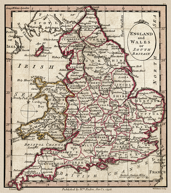
England and Wales or South Britain. Map shows geographic divisions in 1804. This historic map reproduction brings out many details and landmarks,... more
Care Instructions
Machine wash cold and tumble dry with low heat.
Ships Within
1 - 2 business days
"England and Wales or South Britain." Map shows geographic divisions in 1804. This historic map reproduction brings out many details and landmarks, making this map a great historical reference. I have selected interesting, old graphic images for digital restoration and editing. The images were adjusted and brightened-not merely scanned-to make the images suitable for display and other purposes. © 2020 for this restored reproduction.
I live in the United States and use mostly Nikon and Sony equipment. My work includes fine art photography, B&W imagery, and enhanced, restored reproductions of old images and maps. Many of my images displayed here can be licensed through http://licensing.pixels.com. Please contact me for any special needs concerning the use of my images. Thank you for stopping by and looking at my work. Feel free to browse my images and comment, if you wish. The 5 x 7 greeting card size is suitable for framing if you would like a small print of one of my images. Please note that images on this site may not be used for any commercial publication or on any personal website without written permission. It is illegal to copy, post, scan or duplicate...
$39.49


There are no comments for England and Wales 1804 Map. Click here to post the first comment.