Sale on canvas prints! Use code FAXEBY at checkout for a special discount!

Boundary: Bleed area may not be visible.


by Phil Cardamone
$26.00
Size
Image Size
Background Color
Product Details
Purchase a tote bag featuring the photograph "1840 Map of Great Britain and Ireland" by Phil Cardamone. Our tote bags are made from soft, durable, poly-poplin fabric and include a 1" black strap for easy carrying on your shoulder. All seams are double-stitched for added durability. Each tote bag is machine-washable in cold water and is printed on both sides using the same image.
Design Details
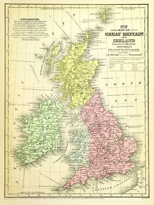
Old antique map reproduced from 19th century atlas: S. AUGUSTUS MITCHELL, J. H. YOUNG Map of Great Britain and Ireland Engraved to Illustrate... more
Ships Within
2 - 3 business days
Old antique map reproduced from 19th century atlas: S. AUGUSTUS MITCHELL, J. H. YOUNG Map of Great Britain and Ireland Engraved to Illustrate Mitchell's School And Family Geography. Map No. 12. Circa 1840.
I have selected interesting, old 19th century graphic images for digital restoration and editing. The images were adjusted and brightened to make the images suitable for display and other purposes.
I live in the United States and use mostly Nikon and Sony equipment. My work includes fine art photography, B&W imagery, and enhanced, restored reproductions of old images and maps. Many of my images displayed here can be licensed through http://licensing.pixels.com. Please contact me for any special needs concerning the use of my images. Thank you for stopping by and looking at my work. Feel free to browse my images and comment, if you wish. The 5 x 7 greeting card size is suitable for framing if you would like a small print of one of my images. Please note that images on this site may not be used for any commercial publication or on any personal website without written permission. It is illegal to copy, post, scan or duplicate...
$26.00


There are no comments for 1840 Map of Great Britain and Ireland. Click here to post the first comment.