Sale on canvas prints! Use code FAXEBY at checkout for a special discount!

Boundary: Bleed area may not be visible.

Inside Message (Optional)
Inside View

by Phil Cardamone
$4.95
Quantity
The more you buy... the more you save.
Orientation
Image Size
Background Color
Product Details
Our greeting cards are 5" x 7" in size and are produced on digital offset printers using 100 lb. paper stock. Each card is coated with a UV protectant on the outside surface which produces a semi-gloss finish. The inside of each card has a matte white finish and can be customized with your own message up to 500 characters in length. Each card comes with a white envelope for mailing or gift giving.
Design Details
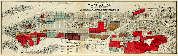
Map of of Manhattan and part of the Bronx showing location and racial populations published 1920, restored reproduction. Originally the map was a... more
Ships Within
2 - 3 business days
Map of of Manhattan and part of the Bronx showing location and racial populations published 1920, restored reproduction. Originally the map was a product of fear that certain "unassimilated" groups might have seditious sympathies ("The Red Scare") at the time of the Bolshevik Revolution in Russia . [Also see a similar map of Manhattan]. This map was a commercial edition based on state government maps produced by the New York State Joint Legislative Committee to Investigate Seditious Activities. Nowadays, the map can be viewed as reflecting the nation's ethnic and immigration heritage. [See similar map of Brooklyn]
I have selected interesting, old 19th and early 20th century graphic images for digital restoration and editing. The images were then adjusted and brightened, not just scanned, to make the images suitable for display and other purposes. The resulting image brings out many details and landmarks, making this map a great historical reference and conversation piece. © 201...
I live in the United States and use mostly Nikon and Sony equipment. My work includes fine art photography, B&W imagery, and enhanced, restored reproductions of old images and maps. Many of my images displayed here can be licensed through http://licensing.pixels.com. Please contact me for any special needs concerning the use of my images. Thank you for stopping by and looking at my work. Feel free to browse my images and comment, if you wish. The 5 x 7 greeting card size is suitable for framing if you would like a small print of one of my images. Please note that images on this site may not be used for any commercial publication or on any personal website without written permission. It is illegal to copy, post, scan or duplicate...
$4.95


Phil Cardamone
Indiana purchaser. Thank you.
Phil Cardamone
A large print for a New York buyer. Thank you.
Richard Jansen
Congratulations