Sale on canvas prints! Use code FAXEBY at checkout for a special discount!

Boundary: Bleed area may not be visible.


by Phil Cardamone
$45.89
Size
Orientation
Material
Image Size
Warning
The image is near the edges of the product but doesn't cover the entire product. Some of the background color may appear around the outside edges of the image.
Background Color
Product Details
Our luxuriously soft blankets are available in two different sizes and feature incredible artwork on the top surface. The bottom surface is white. Our 100% polyester blankets are available in two different styles: plush fleece and sherpa fleece. Plush fleece blankets are soft and fluffy on both sides, whereas sherpa blankets are smooth like a soft sweater on the artwork side (i.e. shorter threads) which provides for a sharper image. Looking for a recommendation? Go with a 60" x 80" plush fleece blanket. It's soft and luxurious on both sides... the artwork looks incredible... and the size is just right for everyone.
Design Details
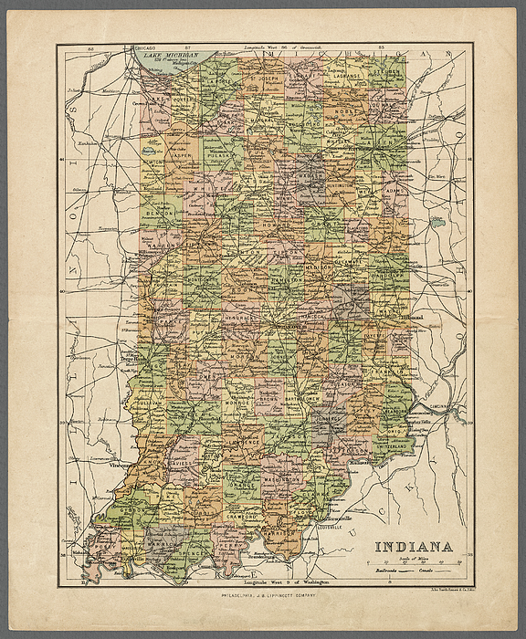
Indiana antique map showing counties, railroads, and canals, published circa, 1890, a digitally restored historic map. Note that many maps of this... more
Care Instructions
Machine wash cold and tumble dry with low heat.
Ships Within
1 - 2 business days
Indiana antique map showing counties, railroads, and canals, published circa, 1890, a digitally restored historic map. Note that many maps of this era gave longitude from Washington, DC, as well as Greenwich, probably in an effort to reduce British domination of cartography. I have selected interesting, old 19th and early 20th century graphic images for digital restoration and editing. The images were then digitally adjusted, enhanced, adjusted, and brightened to make the images suitable for display and other purposes. The resulting image brings out many details and landmarks, making this map a great historical reference and conversation piece. © 2020 for this restored reproduction.
I live in the United States and use mostly Nikon and Sony equipment. My work includes fine art photography, B&W imagery, and enhanced, restored reproductions of old images and maps. Many of my images displayed here can be licensed through http://licensing.pixels.com. Please contact me for any special needs concerning the use of my images. Thank you for stopping by and looking at my work. Feel free to browse my images and comment, if you wish. The 5 x 7 greeting card size is suitable for framing if you would like a small print of one of my images. Please note that images on this site may not be used for any commercial publication or on any personal website without written permission. It is illegal to copy, post, scan or duplicate...
$45.89


There are no comments for Indiana antique map showing counties, railroads, and canals, published circa, 1890. Click here to post the first comment.